INTRODUCTION
You are driving down a dark, unfamiliar highway. The rain is pouring, the road signs are a blurry mess, and you’ve just missed your exit. Panic briefly sets in, but then, a calm, digitized voice emits from your dashboard: “Rerouting. Turn around in 500 feet.”
You glance at the glowing map on your phone. A tiny blue dot perfectly mirrors your car’s movement, gliding seamlessly across the digital asphalt. You let out a breath, make the turn, and head home.
We experience this exact scenario billions of times a day. We use it to find the nearest coffee shop, track our pizza deliveries, and navigate across oceans. Yet, if you stop and think about it for just one second, what is happening on that screen is nothing short of technological witchcraft.
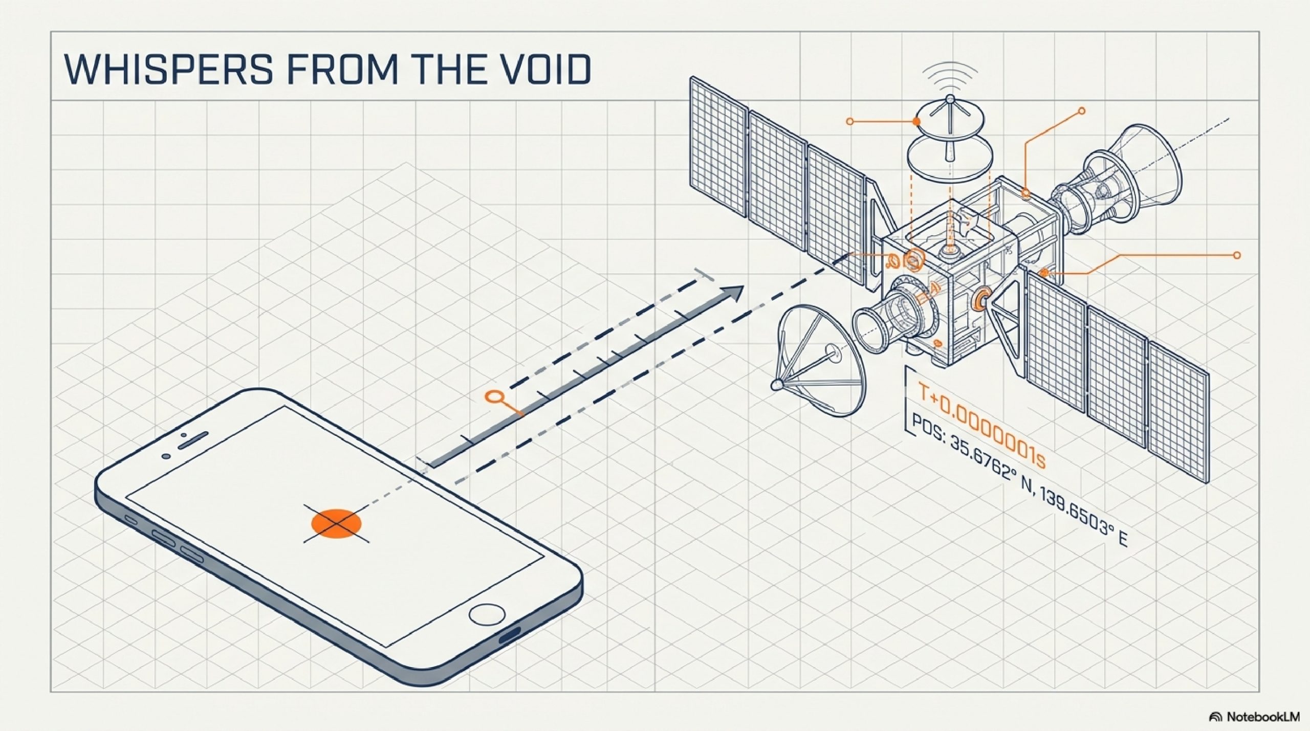
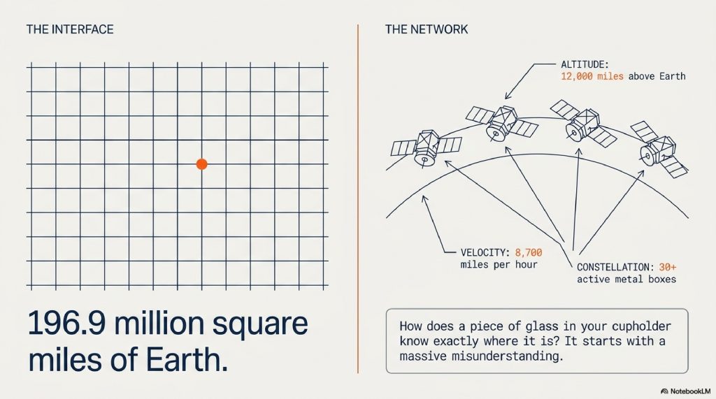
How does a rectangular piece of glass and metal sitting in your cupholder know exactly where it is on a planet of 196.9 million square miles?
Most people assume their phone is sending a signal up to a satellite, asking, “Where am I?” and the satellite is looking down, finding you, and beaming the answer back. This is completely false. Your phone isn’t talking to the satellites at all. In fact, the GPS satellites orbiting our planet have absolutely no idea who you are, where you are, or that you even exist.
The real story involves a constellation of metal boxes flying 12,000 miles above your head at 8,700 miles per hour, shouting the time into the void. It involves atomic clocks, the speed of light, and the mind-bending physics of Albert Einstein’s theory of relativity.
If that sounds like a sci-fi movie, that’s because the reality of the Global Positioning System (GPS) is far stranger and far more brilliant than the simple map on your screen implies. Let’s strip away the interface and look at the invisible, clockwork precision happening right above your head.
TABLE OF CONTENTS
- The Great Illusion: Your Phone is Just Listening
- The Simple Explanation: The Thunder and Lightning Trick
- The Math of Where You Are: Step-by-Step Trilateration
- Real-World Example: Waking Up the Blue Dot
- The Master Timekeepers: Why Atomic Clocks Matter
- Einstein’s Ghost: The Advanced Layer of Relativity
- Common Myths About GPS
- The Future of Navigation: GPS Block III and Beyond
- Fascinating Facts You Didn’t Know About GPS
- FAQs
The Great Illusion: Your Phone is Just Listening
The biggest misconception about GPS is that it is a two-way conversation. It isn’t. GPS is a one-way broadcast.
Think of a GPS satellite like a lighthouse, and your phone like a ship. The lighthouse doesn’t know the ship is there. It doesn’t track the ship. It simply shines its light in all directions. The ship’s captain sees the light and uses it to figure out their own position.
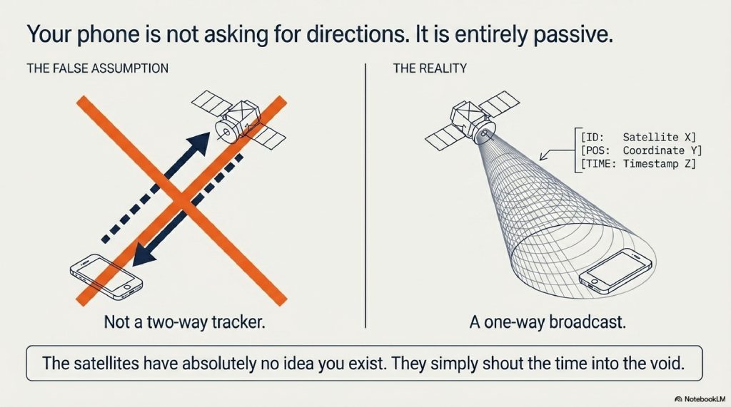
Currently, there are over 30 active GPS satellites orbiting the Earth. At any given moment, no matter where you are standing on the globe, there is a direct line of sight to at least four of them. These satellites are doing only one thing: constantly broadcasting a radio signal that essentially says:
“I am Satellite X. My current position is Y. The exact time I sent this message is Z.”
Your phone’s only job is to listen to these whispers from space.
The Simple Explanation: The Thunder and Lightning Trick
To understand how listening to a satellite tells you your location, we need to look at how we measure distance using speed and time.
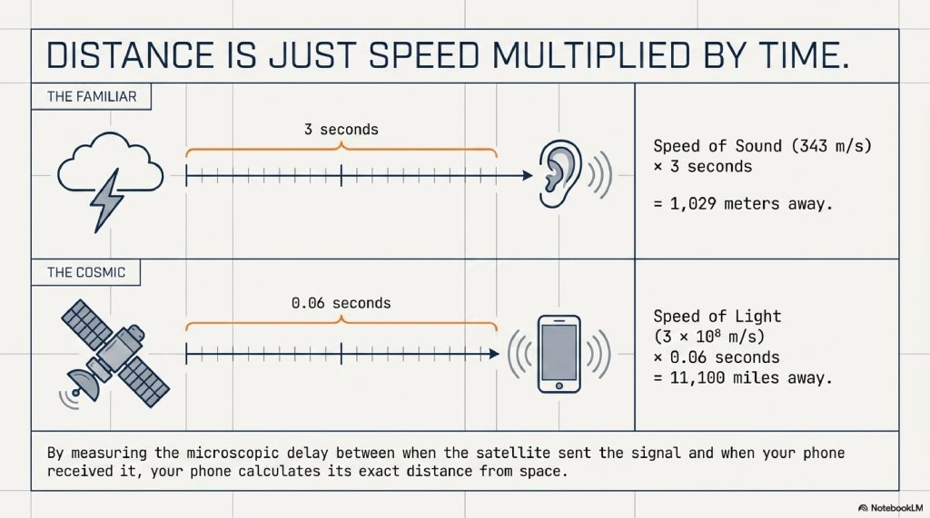
Imagine you are standing in a field. You see a flash of lightning, and three seconds later, you hear the thunder. Because you know the speed of sound is roughly 343 meters per second, you can do some quick mental math:
Distance = Speed × Time
343 meters/second × 3 seconds = 1,029 meters away. You now know exactly how far away the lightning strike was.
GPS works on the exact same principle, but instead of sound waves, it uses radio waves, which travel at the speed of light.
When your phone receives a signal from a satellite, it looks at the timestamp of when the satellite sent the signal, and compares it to the time your phone received the signal. The difference might be a fraction of a second, say, 0.06 seconds.
Because radio waves travel at a constant speed , your phone multiplies that 0.06-second delay by the speed of light. Presto. Your phone now knows it is exactly 11,100 miles away from that specific satellite.
But knowing your distance from one satellite isn’t enough.
The Math of Where You Are: Step-by-Step Trilateration
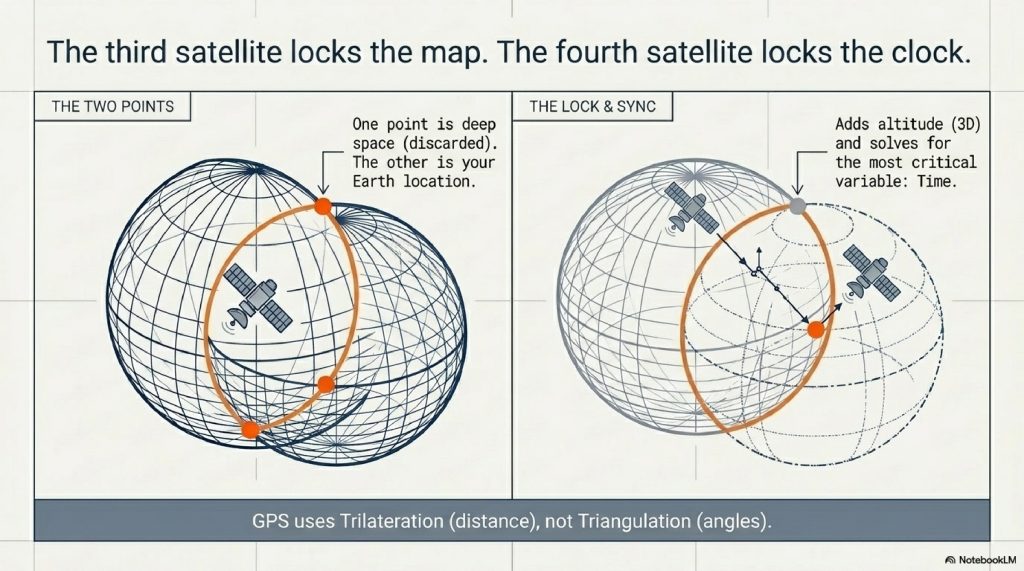
Many people use the word “triangulation” when talking about GPS. But that’s actually incorrect. Triangulation uses angles. GPS uses a geometry principle called trilateration, which relies entirely on distance.
Here is exactly what happens behind the scenes in your phone’s processor:
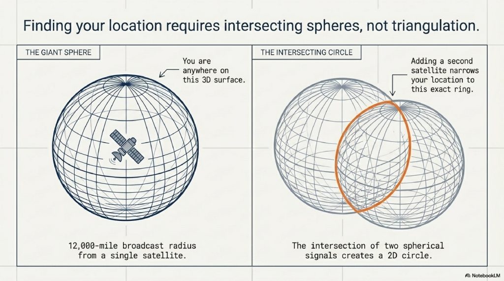
Step 1: The First Satellite (The Giant Sphere)
Your phone connects to Satellite 1. It calculates the time delay and figures out it is exactly 12,000 miles away from Satellite 1.
Imagine a giant, invisible sphere in space, with Satellite 1 at the center, and a radius of 12,000 miles. Your phone could be anywhere on the surface of that massive sphere.
Step 2: The Second Satellite (The Intersecting Circle)
Your phone connects to Satellite 2. It calculates it is 13,000 miles away from this one.
Now, draw a second sphere. Where do these two giant spheres intersect? They intersect to form a perfect, two-dimensional ring. Your phone knows it is somewhere on that specific ring.
Step 3: The Third Satellite (The Two Points)
Your phone connects to Satellite 3. It calculates it is 11,500 miles away.
Draw a third sphere. When a third sphere intersects with the ring from Step 2, it narrows your possible location down to exactly two specific points in space.
One of those points is usually out in deep space or moving at impossible speeds. The other point is on the surface of the Earth. Your phone discards the ridiculous point, and boom, it has your 2D location (Latitude and Longitude).
Step 4: The Fourth Satellite (Altitude and Time Correction)
A fourth satellite is required to nail down your 3D location (adding Altitude) and, most importantly, to synchronize your phone’s relatively cheap internal clock with the multi-million dollar atomic clocks on the satellites. (More on this later).
Real-World Example: Waking Up the Blue Dot
Let’s ground this in reality. You step out of an airport in Tokyo and open Google Maps.
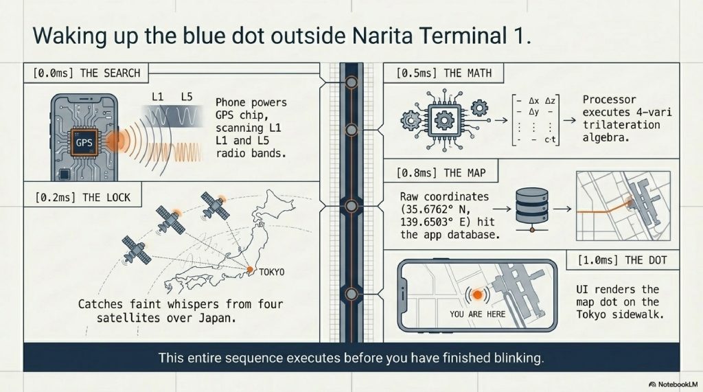
- The Search: Your phone’s GPS chip powers up and starts scanning the specific radio frequencies (L1 and L5 bands) used by GPS satellites.
- The Lock: It catches the faint signals from four different satellites orbiting above Japan.
- The Math: In a fraction of a millisecond, the chip runs the trilateration equations.
- The Map Layer: The raw GPS coordinates (e.g., 35.6762° N, 139.6503° E) are handed over to the Google Maps app. The app references its massive database of roads, realizes those coordinates match the sidewalk outside Narita Terminal 1, and renders a blue dot on your screen.
All of this happens before you’ve even finished blinking.
The Master Timekeepers: Why Atomic Clocks Matter
Up to this point, the system sounds relatively straightforward. But there is a massive engineering hurdle we haven’t discussed: Time.
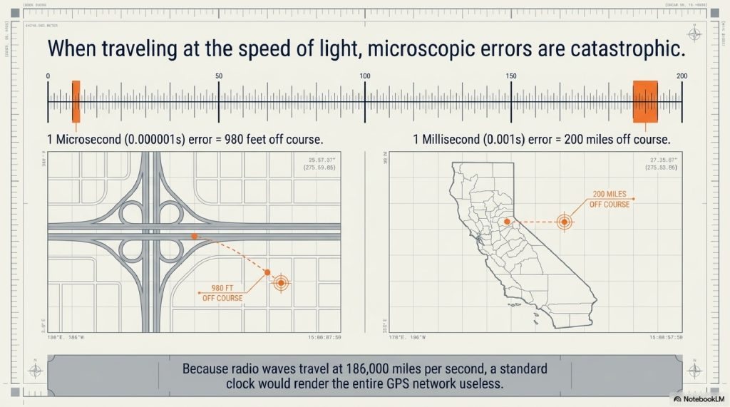
Radio waves travel at the speed of light, roughly 186,000 miles per second. This means that in just one millionth of a second (a microsecond), a GPS radio signal travels about 980 feet (300 meters).
If the clock inside the satellite and the clock inside your phone are out of sync by just one single millisecond, the distance calculation will be off by nearly 200 miles. Your phone would think you were in a different state.
To solve this, every GPS satellite carries multiple Atomic Clocks.
Atomic clocks don’t use gears or quartz crystals. They measure time by tracking the predictable vibrations of atoms (usually rubidium or cesium) as they transition between energy states. They are so precise they will not lose or gain a single second in 100 million years.
Your smartphone, however, does not have a $100,000 atomic clock inside it. It has a cheap quartz clock. So how do they sync?
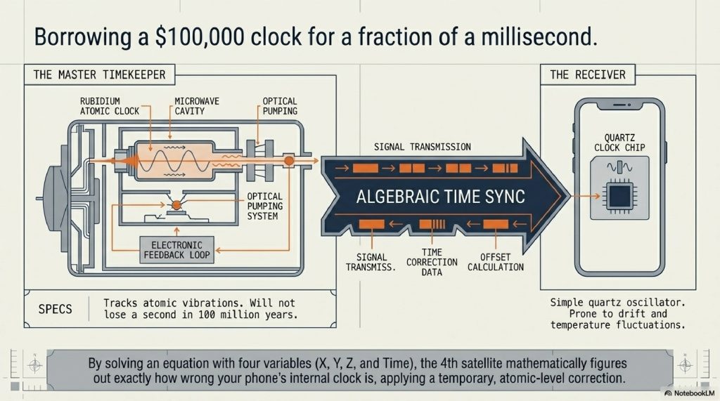
This is where the magic of the Fourth Satellite comes in. By measuring the signals from four satellites instead of three, your phone’s software can solve an algebraic equation with four variables (X, Y, Z coordinates, and Time). It mathematically figures out exactly how wrong its own internal clock is, and applies a correction. In that fleeting moment of connection, your smartphone temporarily possesses atomic-clock accuracy.
Einstein’s Ghost: The Advanced Layer of Relativity
If atomic clocks were the only hurdle, GPS would be a marvel of engineering. But nature threw an incredibly complex curveball at the architects of the system: the universe itself warps time.
To make GPS work, engineers literally have to program Albert Einstein’s theories of relativity into the software. Here is the mind-bending reality:
1. Special Relativity (Speed Slows Time)
Einstein proved that the faster an object moves, the slower time passes for that object relative to a stationary observer. Because GPS satellites are moving at 8,700 mph, their onboard atomic clocks tick slower than the clocks on Earth by about 7 microseconds a day.
2. General Relativity (Gravity Speeds Time)
Einstein also proved that mass warps space-time. The closer you are to a massive object (like Earth), the stronger the gravity, and the slower time moves. Because the satellites are 12,000 miles away from Earth, they experience a lot less gravity than we do. Therefore, time moves faster for them by about 45 microseconds a day.
The Net Effect
If you subtract the 7 microseconds (speed) from the 45 microseconds (gravity), you get a net difference: The clocks on the satellites tick 38 microseconds faster every day than the clocks on Earth.
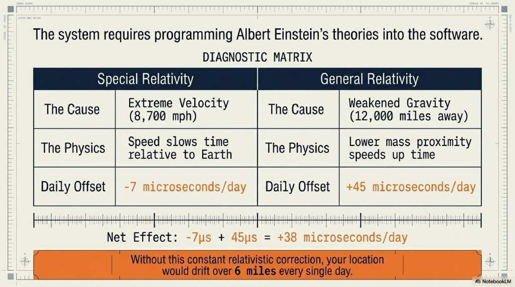
If engineers did not account for this bizarre quirk of physics, the GPS network would lose its accuracy within minutes. Within a single day, your phone’s blue dot would drift by over 6 miles. Every GPS receiver runs a continuous mathematical correction formula to bridge the gap between our gravity-heavy reality and the fast-moving satellites.
Every time you find a coffee shop on your phone, you are proving Einstein right.
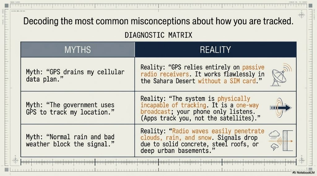
Common Myths About GPS
Myth 1: “GPS drains my data plan.”
Fact: GPS relies on radio receivers, not cellular data. You can pull the SIM card out of your phone, go to the middle of the Sahara Desert without a single bar of cell service, and your GPS will still pinpoint your location perfectly. (Though you won’t be able to load the map imagery without data).
Myth 2: “The government tracks me using my GPS.”
Fact: As we learned, GPS is a one-way street. The satellites broadcast, and your phone listens. The GPS system itself physically cannot track you. However, the apps on your phone (like Google Maps or Facebook) take that GPS data and send it over Wi-Fi or cellular networks to their own servers.
Myth 3: “Bad weather affects GPS.”
Fact: While severe solar storms can mess with the ionosphere and delay signals, normal rain, clouds, and snow have almost zero effect on the radio waves used by GPS. If your signal drops in a storm, it’s likely a hardware or cellular mapping issue, not the satellites.
The Future of Navigation: GPS Block III and Beyond
The GPS system is old. The first experimental satellite was launched in 1978. But the system is currently undergoing a massive, multi-billion-dollar upgrade.
Enter GPS Block III.
These next-generation satellites are currently being launched into orbit by SpaceX and the US Space Force. They offer massive upgrades over the older tech:
- 3x Greater Accuracy: Shrinking the margin of error from a few meters down to 1-3 feet.
- 8x Stronger Anti-Jamming: Crucial for military and commercial aviation security.
- The L5 Signal: A new civilian frequency that penetrates buildings and tree canopies much better, ending the frustration of losing your signal in dense city centers or forests.
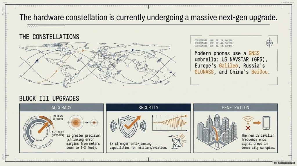
Furthermore, GPS is no longer alone. The system we call “GPS” is technically the US military’s NAVSTAR system. Today, modern smartphones also listen to Europe’s Galileo, Russia’s GLONASS, and China’s BeiDou constellations. Collectively known as GNSS (Global Navigation Satellite Systems), your phone is now listening to dozens of satellites simultaneously to lock in an ultra-precise location.
Fascinating Facts You Didn’t Know About GPS
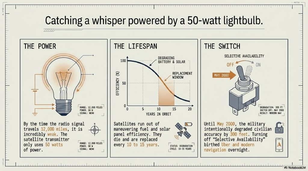
- Selective Availability: Until May 2nd, 2000, the US military intentionally degraded the civilian GPS signal to make it inaccurate by about 300 feet, keeping the true accuracy for the military. President Bill Clinton ordered it turned off, instantly giving the world pinpoint navigation overnight and birthing industries like Uber and Geocaching.
- The Power of a Lightbulb: By the time a GPS signal reaches your phone from 12,000 miles away, it is incredibly weak. The transmitter on the satellite only uses about 50 watts of power less than a standard incandescent lightbulb.
- Atomic Lifespans: The satellites don’t last forever. They run out of maneuvering fuel and their solar panels degrade. The average lifespan of a GPS satellite is about 10 to 15 years, requiring constant replacement launches.
FAQs
1. Can GPS work without internet or cellular service?
Yes. GPS is a completely separate hardware system in your phone that receives radio waves from satellites. However, to see the map underneath your blue dot, you usually need the internet, unless you download the maps offline in advance.
2. Why does my GPS struggle when I’m inside a building?
The radio signals from GPS satellites are incredibly weak by the time they reach Earth. While they can pass through clouds, glass, and plastic, they are easily blocked by solid structures like concrete, steel roofs, and deep basements.
3. What is the difference between GPS and GNSS?
GPS specifically refers to the United States’ satellite navigation system. GNSS (Global Navigation Satellite System) is the umbrella term that includes GPS, Europe’s Galileo, Russia’s GLONASS, and China’s BeiDou. Modern phones use GNSS to access all of them.
4. How accurate is the GPS on my smartphone?
Under open skies, most modern smartphone GPS chips are accurate to within a 4.9-meter (16-foot) radius. With the adoption of dual-frequency (L1/L5) receivers, this is shrinking to mere centimeters.
5. Does using GPS drain my battery faster?
Yes. To calculate your location, the GPS chip in your phone has to constantly stay awake, listen to multiple satellite frequencies, and run complex mathematical algorithms every second. This requires significant processing power.
6. Who owns and operates the GPS system?
The Global Positioning System is owned by the United States government and is operated by the United States Space Force. It is provided as a free utility to the world.
7. Can GPS satellites be hacked?
The satellites themselves are highly secure military assets, making hacking them incredibly difficult. However, local GPS signals can be “spoofed” or jammed by bad actors on the ground using specialized radio equipment to feed fake locations to nearby receivers.
8. Why does my location sometimes “jump” around on the map?
This is often caused by the “urban canyon” effect. If you are surrounded by tall skyscrapers, the satellite signal bounces off the glass and steel buildings before reaching your phone, causing the time-delay calculation to be slightly wrong.
9. How many satellites do you need for a location?
You need an absolute minimum of three satellites for a 2D location (latitude and longitude). You need four satellites to determine a 3D location (adding altitude) and to sync your phone’s clock.
10. Do airplanes use the same GPS as my phone?
They use the same satellites, but commercial aviation relies on specialized, highly regulated receivers combined with ground-based augmentation systems (WAAS) to ensure fail-safe accuracy for landing in zero-visibility conditions.
OTHER BLOG SUGGESTIONS
To keep readers engaged and improve your site’s SEO architecture, consider linking to these related topics:
- Why Public Wi-Fi is Dangerous: The Invisible Risks Explained
- How Hackers Steal Passwords Without You Realizing
- How Google Search Actually Ranks Websites in 2026
- How Websites Track You Across the Internet (Explained Simply)
CONCLUSION
The next time you pull up a map on your phone and watch that little blue dot lock into place, take a moment to appreciate the sheer scale of the invisible infrastructure making it happen.
You are holding a device that reaches across thousands of miles of empty space to catch the whispers of flying atomic clocks. You are holding a device that bends the rules of time and gravity, consulting the ghost of Albert Einstein to ensure you don’t miss your exit on the highway.
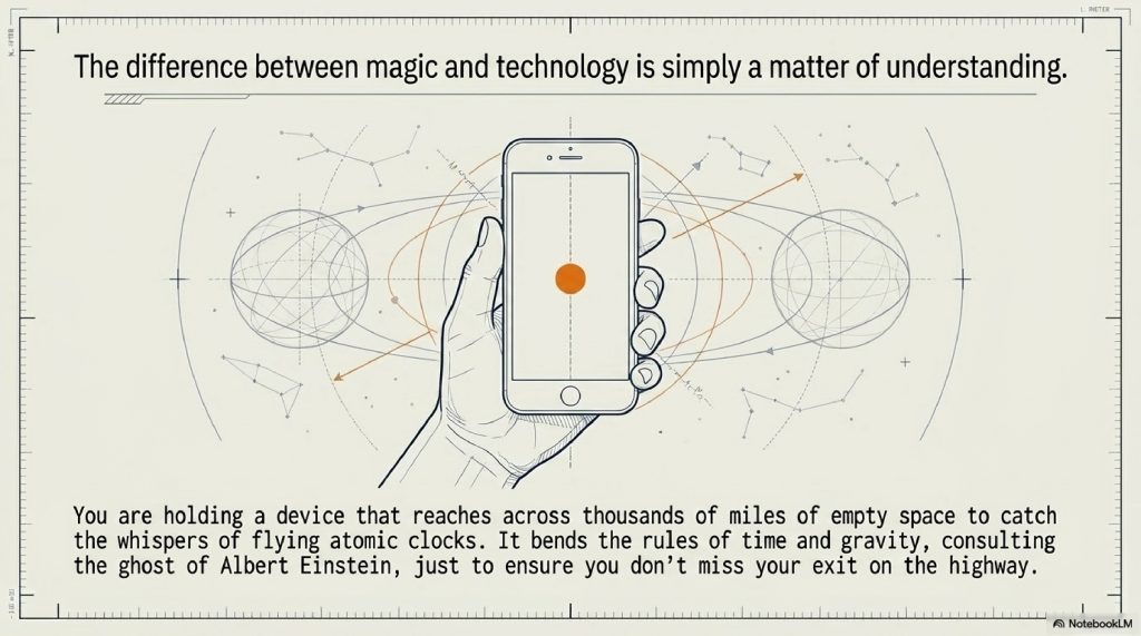
GPS is not just a tool for finding coffee shops or navigating traffic. It is a masterpiece of human ingenuity, a silent symphony of mathematics, physics, and aerospace engineering playing out constantly over our heads. It reminds us that magic isn’t real, but when technology gets advanced enough, the difference between the two is simply a matter of understanding.
Comments (2)