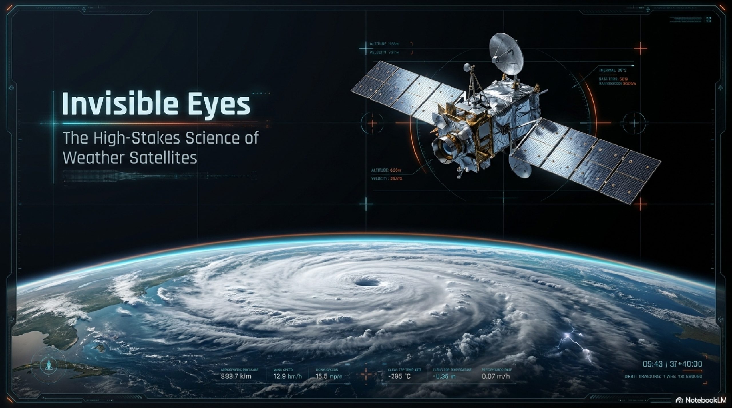
INTRODUCTION
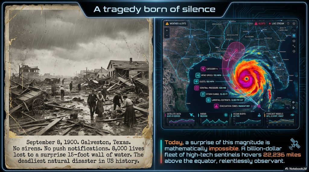
September 8, 1900. The citizens of Galveston, Texas, went about their Saturday chores under a gray, drizzly sky. There were no sirens. No push notifications. No colored maps glowing on television screens. By sunset, a wall of water fifteen feet high swept across the island, claiming the lives of an estimated 8,000 people. It remains the deadliest natural disaster in United States history, a tragedy born of silence.
Today, such a surprise is impossible.
As you read this, a billion-dollar fleet of high-tech sentinels is hovering 22,236 miles above the equator. They are silent, cold, and relentlessly observant. They don’t just “see” the weather; they feel the Earth’s heartbeat. They measure the moisture trapped in the Saharan dust, the temperature of the Pacific’s deep currents, and the subtle shift of wind speeds in the upper atmosphere.
When a hurricane begins as a mere cluster of clouds off the coast of Africa, these satellites are already there. They watch it grow, feed, and spin. They predict its path with such accuracy that we can evacuate entire cities days before the first raindrop hits a windshield.
But how does a piece of metal in the vacuum of space “see” a storm that hasn’t even formed yet? How do we translate invisible heat signatures into the five-day forecast on your smartphone?
We treat the weather forecast like a daily utility, often grumbling when a picnic is ruined by a surprise shower. But the reality is that weather forecasting is the ultimate high-stakes detective story. It is a masterpiece of orbital mechanics, quantum physics, and massive supercomputing.
In this investigative journey, we are going to peel back the layers of our atmosphere. We will uncover how we taught machines to see in the dark, why the math of gravity is the secret to a perfect forecast, and how a new era of Artificial Intelligence is turning these space-bound eyes into the ultimate guardians of humanity.
Welcome to the world of the invisible eyes. Let’s find out how they really work.
TABLE OF CONTENTS
- The Simple Analogy: The Security Guard in the Sky
- The Orbital Dance: Two Ways to Watch a Planet
- The Multi-Spectral Eye: How Satellites See the Invisible
- The Step-by-Step Journey of a Storm Prediction
- The Advanced Technical Layer: Radiometers and Sounding
- The Math of the Heavens: Orbital Physics Explained
- Hunting the Beast: How Hurricanes are Tracked
- Common Myths About Weather Satellites*9. Interesting Facts Section
- The Future: AI and the End of “Surprise” Weather
- FAQ Section
- Conclusion
The Simple Analogy: The Security Guard in the Sky
To understand how a weather satellite works without getting bogged down in jargon, imagine a giant skyscraper in the center of a massive, crowded city.
Most people on the street can only see what is directly in front of them, the car ahead, the shop across the road, or the dark clouds looming a few blocks away. Their perspective is limited by the “horizon” of the buildings around them.
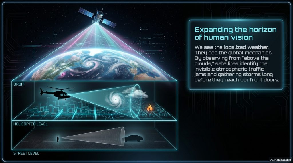
Now, imagine a security guard sitting in a helicopter hovering thousands of feet above that skyscraper. From that height, the guard can see the traffic jam forming ten miles away. They can see the fire three neighborhoods over. They can see the rainstorm approaching from the suburbs while the people downtown are still enjoying the sun.
A weather satellite is that security guard.
But instead of a helicopter, it sits in the vacuum of space. Instead of eyes, it uses sophisticated sensors that can detect heat and moisture. By looking at the Earth from “above the clouds,” it sees the global patterns that are invisible to us on the ground. It identifies the “traffic jams” in our atmosphere (high-pressure systems) and the “fires” (developing storms) before they ever reach our front door.
The Orbital Dance: Two Ways to Watch a Planet
Not all satellites are created equal. To get a perfect forecast, we need two different perspectives, much like a photographer needs both a wide-angle lens and a zoom lens.
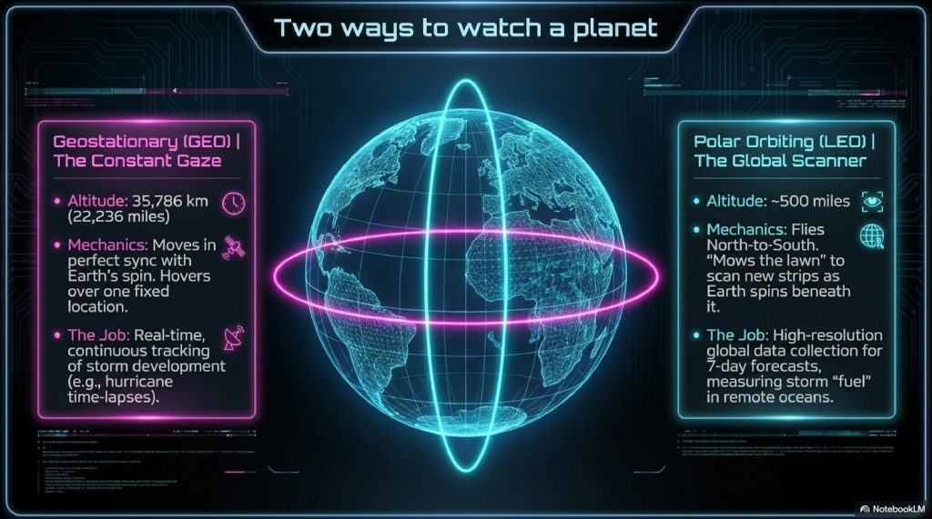
1. Geostationary Orbits (The Constant Gaze)
Imagine a satellite that never moves. It stays perfectly locked over one specific spot, say, the East Coast of the United States 24 hours a day. This is a Geostationary (GEO) satellite.
To do this, the satellite must orbit at a very specific altitude: exactly 35,786 kilometers (22,236 miles). At this height, the time it takes the satellite to circle the Earth matches the time it takes the Earth to rotate once. It “hovers” because it is moving in perfect sync with the planet’s spin.
- The Job: Watching storms develop in real-time. This is how we get those dramatic time-lapse videos of hurricanes spinning in the ocean.
2. Polar Orbits (The Global Scanner)
While GEO satellites stare at one spot, Polar Orbiting (LEO) satellites “mow the lawn.” They fly much closer to Earth (about 500 miles up) and travel from North Pole to South Pole. As the Earth spins beneath them, they scan a new strip of the planet with every pass.
- The Job: Providing high-resolution data for the entire globe. These satellites are the workhorses for long-range, 7-day forecasts because they measure the “fuel” for future storms in places where no one lives, like the deep Arctic or the middle of the Pacific.
The Multi-Spectral Eye: How Satellites See the Invisible
If you looked out the window of a satellite, you’d see a beautiful blue marble. But to predict a storm, a regular photograph isn’t enough. Meteorologists need to see what is hidden. Modern satellites use Multi-spectral Imaging to see the Earth in three “flavors”:
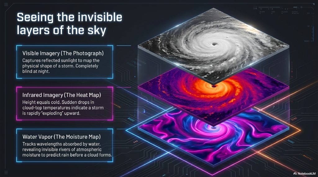
A. Visible Imagery (The Photograph)
This is exactly what your eyes see. It captures sunlight reflecting off cloud tops. It’s great for seeing the shape of a storm, but it’s useless at night.
B. Infrared Imagery (The Heat Map)
Everything on Earth emits heat. Infrared sensors measure this heat.
- The Trick: In our atmosphere, height equals cold. The higher a cloud is, the colder its top becomes.
- The Prediction: If a satellite sees a cluster of clouds suddenly getting much colder, it means those clouds are “exploding” upward. This is a classic sign of a developing thunderstorm or a strengthening hurricane.
C. Water Vapor Imagery (The Moisture Map)
This sensor looks at a specific wavelength that is absorbed by water vapor. It allows us to see the “invisible rivers” of moisture flowing through the air, even when there are no clouds. This is how we predict where rain will form before the first cloud even appears.
The Step-by-Step Journey of a Storm Prediction
How does a signal in space become an alert on your phone? It is a high-speed data pipeline that spans the globe.
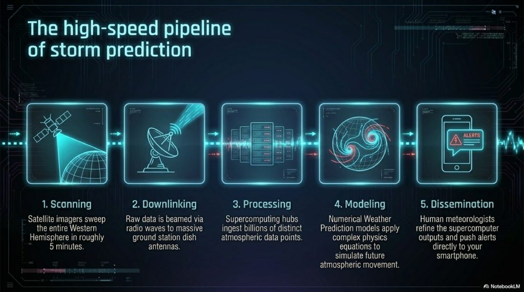
- Scanning: The satellite’s “imager” (like a high-tech scanner) sweeps across the Earth. For a GEO satellite, it can scan the entire Western Hemisphere in about 5 minutes.
- Downlinking: The satellite beams this data down via radio waves to giant dish antennas on Earth (Ground Stations).
- Processing: Raw data is sent to massive supercomputer centers (like NOAA in the US or ECMWF in Europe). These computers ingest billions of data points, temperature, pressure, wind speed, and humidity.
- Modeling: The supercomputers run Numerical Weather Prediction (NWP) models. They use complex physics equations to simulate how the atmosphere will move.
- Dissemination: Meteorologists review the models, add their expertise, and push the forecast to news stations, aviation authorities, and app developers.
The Advanced Technical Layer: Radiometers and Sounding
For the intelligent reader looking for the “how” behind the “what,” we must look at the Advanced Baseline Imager (ABI) and Sounders.
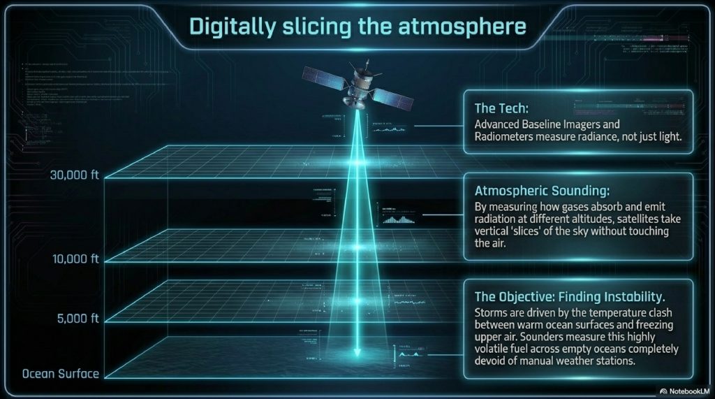
A satellite doesn’t just “take a picture.” It uses a Radiometer. This device measures the “radiance” (energy) coming off the Earth at specific narrow bands of the electromagnetic spectrum.
One of the most impressive feats is Atmospheric Sounding. By measuring how different gases in the air (like Carbon Dioxide or Oxygen) absorb and emit radiation at different altitudes, satellites can “slice” the atmosphere. They can tell you the temperature at 5,000 feet, 10,000 feet, and 30,000 feet simultaneously, without ever touching the air.
This is critical because storms are driven by Instability, the difference in temperature between the warm ground and the cold upper air. Sounders allow us to measure that instability across the entire ocean, where there are no weather stations to take manual readings.
The Math of the Heavens: Orbital Physics Explained
Why doesn’t a satellite just fall out of the sky? It’s a balance of two opposing forces: the pull of gravity and the speed of the satellite.
To stay in a stable orbit, a satellite must travel at a specific velocity so that its “fall” toward Earth perfectly matches the curvature of the Earth.
The formula for the velocity required to maintain a circular orbit at a distance from the center of a planet with mass is:
Where:
- is the gravitational constant
- is the mass of the Earth
- is the distance from the center of the Earth to the satellite.
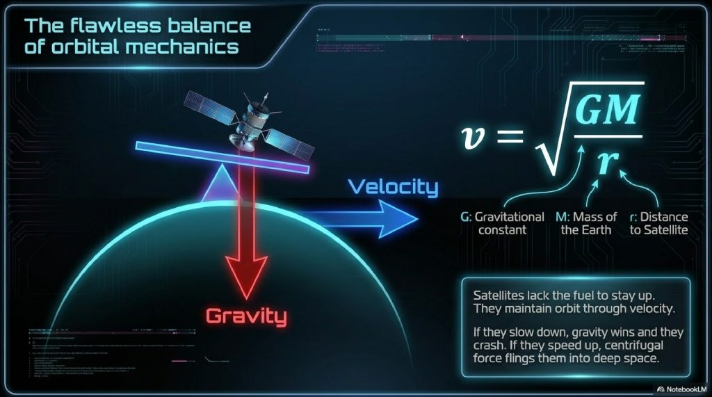
For a Geostationary satellite, must be approximately 42,164 km (radius of Earth + altitude). If the satellite slows down even a little, gravity wins, and it crashes. If it speeds up, centrifugal force wins, and it flings out into deep space. The precision required is staggering.
Hunting the Beast: How Hurricanes are Tracked
When a hurricane is born, satellites look for the “Eyewall” and the “Outflow.”
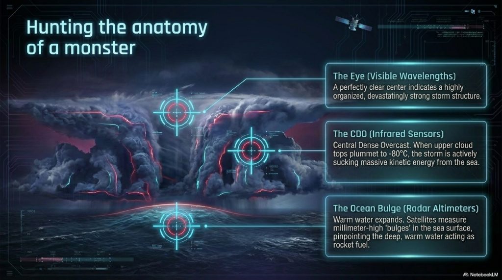
- The Eye: Using high-resolution visible imagery, satellites look for the clearing in the center. A clear eye often means a very strong, organized storm.
- The Temperature Drop: Using Infrared, scientists look at the “CDO” (Central Dense Overcast). If the cloud tops are hitting , the storm is sucking up massive amounts of energy from the warm ocean.
- Ocean Heat Content: Specialized satellites use altimeters to measure the height of the ocean. Warm water expands. By measuring a “bulge” in the ocean surface just a few centimeters high, satellites can tell meteorologists exactly where the “fuel” is for a hurricane to intensify into a Category 5 monster.
Common Myths About Weather Satellites
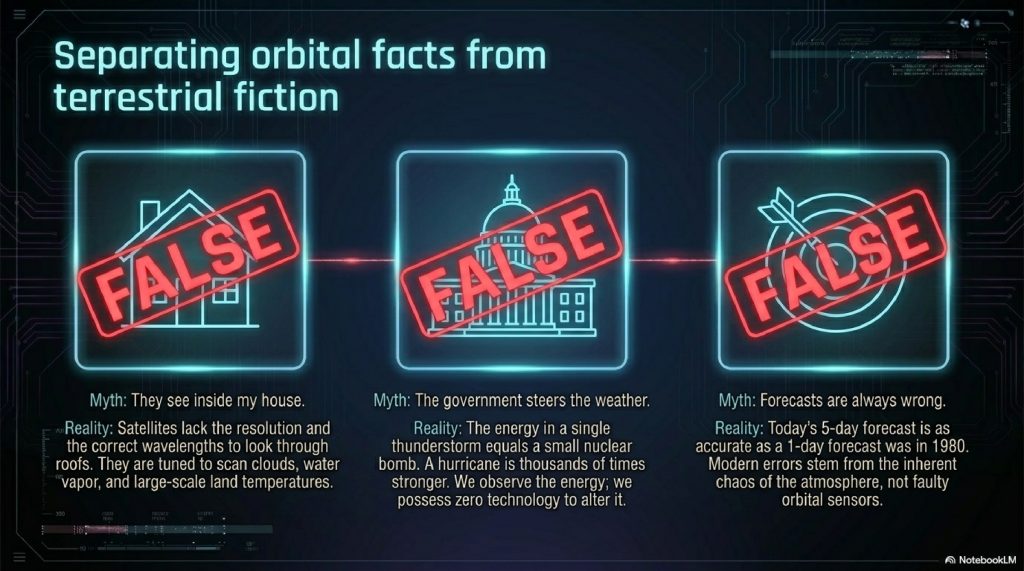
“Satellites can see through my roof.”
Reality: Absolutely not. Weather satellites look at the atmosphere and the Earth’s surface. They use wavelengths designed to detect clouds, water vapor, and land temperature. They don’t have the resolution (or the desire) to see inside your house.
“The government uses satellites to control the weather.”
Reality: This is a popular conspiracy theory with zero basis in physics. The energy in a single medium-sized thunderstorm is roughly equivalent to a small nuclear bomb. A hurricane is thousands of times more powerful. We can observe that energy, but we have no technology capable of creating or steering it.
“Weather satellites are the reason the forecast is always wrong.”
Reality: The forecast is actually incredibly accurate! A 5-day forecast today is as accurate as a 1-day forecast was in 1980. The “error” usually comes from the chaotic nature of the atmosphere (the Butterfly Effect), not the satellites.
Interesting Facts Section
- TIROS-1: The first successful weather satellite was launched on April 1, 1960. It operated for only 78 days but proved that space was the best place to watch the weather.
- Lightning Mappers: The newest GOES satellites carry a “Geostationary Lightning Mapper” that can detect every single flash of lightning across the entire Western Hemisphere, day or night, at 500 frames per second.
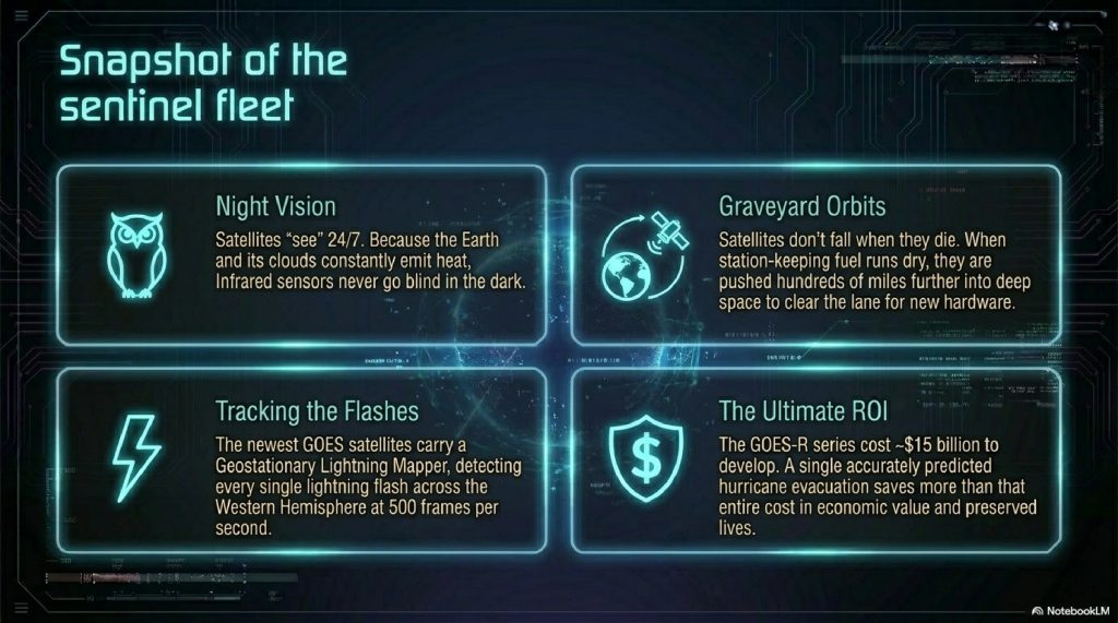
- The $15 Billion Guardians: The GOES-R series of satellites cost roughly $15 billion to develop and launch. It sounds like a lot, but a single well-predicted hurricane evacuation saves more than that in economic value and lives.
- Sun-Synchronous: Some polar satellites are “Sun-Synchronous,” meaning they pass over a specific spot at the exact same local solar time every day. This ensures the shadows are always the same, making it easier for computers to spot changes on the ground.
The Future: AI and the End of “Surprise” Weather
The next revolution isn’t just about better cameras; it’s about better brains.
Currently, supercomputers use “Physics-based” models, they try to calculate every molecule of air. It’s slow. A new generation of AI-based weather models (like Google’s GraphCast or NVIDIA’s Earth-2) is being trained on 40 years of historical satellite data.
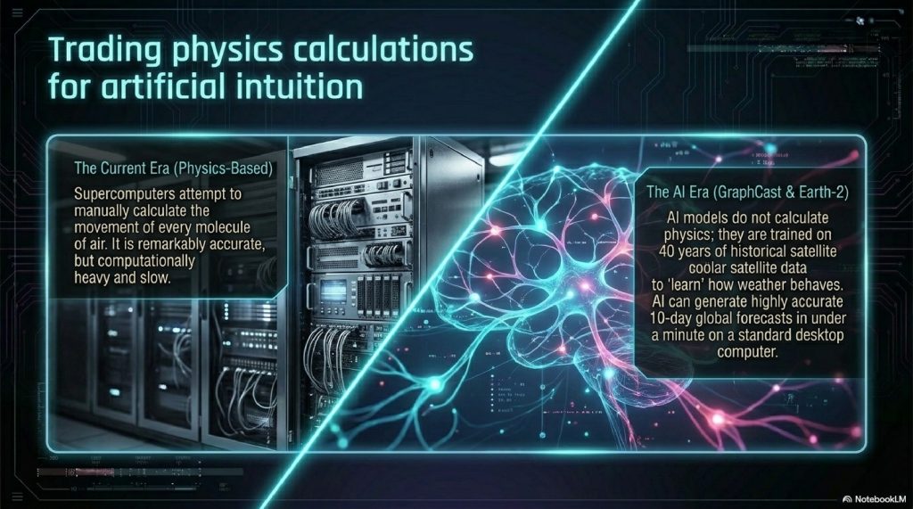
Instead of calculating physics, the AI has “learned” how weather moves. These AI models can now produce a 10-day global forecast in under a minute on a single desktop computer, with accuracy that matches or beats the world’s biggest supercomputers.
Combined with CubeSats, swarms of tiny, cheap satellites the size of a shoebox, we are entering an era where every square mile of the planet will be monitored in high-definition, every second. The “surprise” storm is becoming a relic of history.
FAQ SECTION
1. Can weather satellites work at night?
Yes. While they can’t take “visible” photos without the sun, they use Infrared sensors to detect heat. Since clouds and the Earth are always emitting heat, satellites “see” 24/7.
2. How do satellites stay in space without fuel?
They use fuel for small “station-keeping” adjustments, but for the most part, they stay up due to orbital velocity. They are effectively “falling” around the Earth at the same rate the Earth curves away from them.
3. What is the difference between Radar and Satellite?
Radar (on the ground) shoots radio waves at rain and measures the bounce-back. It “sees” what is falling now. Satellites (in space) “see” the clouds and moisture that will cause rain later.
4. Can satellites see wind?
Satellites can’t see clear air, but they track “cloud motion vectors”, they watch how fast clouds or water vapor plumes move to calculate the wind speed at different heights.
5. How far in advance can satellites predict a hurricane?
Satellites can spot the “seed” of a hurricane (a tropical wave) up to two weeks before it becomes a named storm.
6. Why are satellites so high up?
Geostationary satellites must be at 22,236 miles because that is the only place where gravity allows them to orbit at the same speed the Earth rotates.
7. Does heavy rain block a satellite’s view?
Visible and Infrared sensors can’t see through clouds, but they see the top of the clouds. However, “Microwave” sensors can actually see through clouds to detect rain and ice inside the storm.
8. What happens to old weather satellites?
When they run out of fuel, they are moved to a “Graveyard Orbit” a few hundred miles further out to make room for new ones.
9. Can satellites measure sea-level rise?
Yes. Using “Altimeters,” they bounce radar pulses off the ocean to measure its height with millimeter precision, tracking climate change globally.
10. How many weather satellites are there?
There are dozens of operational weather satellites from various countries (USA, Europe, Japan, China, India) that all share data to create a global map.
OTHER USEFUL BLOG SUGGESTIONS
- How Do Rocket Engines Work? The Science of Space Propulsion
- How SpaceX Reuses Rockets: The technology used to launch these satellites into orbit.
- How Mobile Towers Work: How the weather data finally reaches your phone.
CONCLUSION
The blue dot on your weather app is a quiet triumph of human ingenuity.
Every time you see a storm warning, you are benefiting from a chain of events that begins with a forged titanium plate in a cleanroom, travels on a pillar of fire into the silent vacuum of space, and relies on the same gravitational math that keeps the moon in its place.
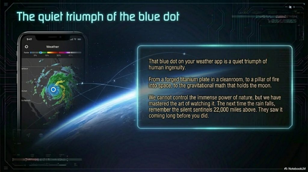
We have come a long way from the residents of Galveston staring hopelessly at a gray horizon. We have successfully surrounded our planet with an invisible web of sensors, a mechanical nervous system that feels the heat, sees the wind, and warns us of danger.
Weather satellites remind us that while we cannot control the power of nature, we have mastered the art of watching it. We are no longer blind to the sky. And as we refine our space-bound eyes with the power of Artificial Intelligence, the world becomes a little safer, a little more predictable, and a lot more awe-inspiring.
The next time the rain begins to fall, remember the silent sentinels 22,000 miles above. They saw it coming long before you did.
Comments (2)